Ionian Sea
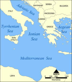
The Ionian Sea is an arm of the Mediterranean Sea, south of the Adriatic Sea. It is bounded by southern Italy including Calabria, Sicily and the Salento peninsula to the west, and by southwestern Albania, including Saranda and Himara, and a large number of Greek islands, including Corfu, Zante, Kephalonia, Ithaka, and Lefkas to the east. The islands are collectively referred to as the Ionian Islands, and other islands include the Strophades, Sphagia, Schiza, Sapientza and Kythira. The sea is one of the most seismic areas in the world.
There are ferry routes between Patras and Igoumenitsa, Greece, and Brindisi and Ancona, Italy, that cross the east and north of the Ionian Sea, and from Piraeus westward. Calypso Deep, the deepest point in the Mediterranean at -5,267 metres (−17,280.2 ft), is located in the Ionian Sea, at .[1][2]
Contents |
Geography
Extent
The International Hydrographic Organization defines the limits of the Ionian Sea as follows:[3]
On the North. A line running from the mouth of the Butrinto River (39°44'N) in Albania, to Cape Karagol in Corfu (39°45'N), along the North Coast of Corfu to Cape Kephali (39°45'N) and from thence to Cape Santa Maria di Leuca in Italy.
On the East. From the mouth of the Butrinto River in Albania down the coast of the mainland to Cape Matapan.
On the South. A line from Cape Matapan to Cape Passero, the Southern point of Sicily.
On the West. The East coast of Sicily and the Southeast coast of Italy to Cape Santa Maria di Leuca.
Places
From south to north in the west, then north to south in the east:
- Syracuse, port, W
- Catania, port, W
- Taranto, port N
- Saranda, port and a beach, NE
- Parga, small port
- Preveza, port, E
- Ancient Paleros
- Astakos
- Fiskardo, small port
- Keri, no port
- Zacharo, beach and thermal springs
- Methoni, small port and a beach
- Ionian Islands
Gulfs and straits
- Strait of Messina, W
- Gulf of Catania, W
- Gulf of Taranto, NW
- Ambracian Gulf, E
- Gulf of Patras, connecting the Gulf of Corinth, ESE
- Gulf of Kyparissia, SE
- Messenian Gulf, SE
- Laconian Gulf, ESE
See also
- Calypso Deep
References
- ↑ Barale, Vittorio (2008). "The European Marginal and Enclosed Seas: An Overview". In Vittorio Barale and Martin Gade (eds). Remote Sensing of the European Seas. Springer Science+Business Media. pp. 3–22. LCCN 2007-942178. ISBN 978-1402067716. http://books.google.com/books?id=9B3D5-HBTzkC&pg=PA14&dq=%22Calypso+Deep%22#v=onepage&q=%22Calypso%20Deep%22&f=false. Retrieved 28 August 2009.
- ↑ NCMR - MAP
- ↑ "Limits of Oceans and Seas, 3rd edition". International Hydrographic Organization. 1953. http://www.iho-ohi.net/iho_pubs/standard/S-23/S23_1953.pdf. Retrieved 7 February 2010.
|
||||||||||||||||||||
External links
- Preveza Weather Station SV6GMQ - Live Weather Conditions (in English and Greek)